About the CoMSES Model Library more info
Our mission is to help computational modelers at all levels engage in the establishment and adoption of community standards and good practices for developing and sharing computational models. Model authors can freely publish their model source code in the Computational Model Library alongside narrative documentation, open science metadata, and other emerging open science norms that facilitate software citation, reproducibility, interoperability, and reuse. Model authors can also request peer review of their computational models to receive a DOI.
All users of models published in the library must cite model authors when they use and benefit from their code.
Please check out our model publishing tutorial and contact us if you have any questions or concerns about publishing your model(s) in the Computational Model Library.
We also maintain a curated database of over 7500 publications of agent-based and individual based models with additional detailed metadata on availability of code and bibliometric information on the landscape of ABM/IBM publications that we welcome you to explore.
Displaying 10 of 127 results spatial clear search
Potato late blight model
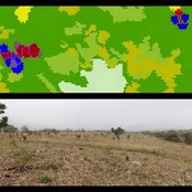
Francine Pacilly | Published Friday, April 13, 2018The purpose of the model is to simulate the spatial dynamics of potato late blight to analyse whether resistant varieties can be used effectively for sustainable disease control. The model represents an agricultural landscape with potato fields and data of a Dutch agricultural region is used as input for the model. We simulated potato production, disease spread and pathogen evolution during the growing season (April to September) for 36 years. Since late blight development and crop growth is weather dependent, measured weather data is used as model input. A susceptible and late blight resistant potato variety are distinguished. The resistant variety has a potentially lower yield but cannot get infected with the disease. However, during the growing season virulent spores can emerge as a result of mutations during spore production. This new virulent strain is able to infect the resistant fields, resulting in resistance breakdown. The model shows how disease severity, resistance durability and potato yield are affected by the fraction of fields across a landscape with a disease-resistant potato variety.
PolicySpace: agent-based modeling
B Furtado Isaque Daniel Rocha Eberhardt Francis Tseng | Published Tuesday, March 06, 2018PolicySpace models public policies within an empirical, spatial environment using data from 46 metropolitan regions in Brazil. The model contains citizens, markets, residences, municipalities, commuting and a the tax scheme. In the associated publications (book in press and https://arxiv.org/abs/1801.00259) we validate the model and demonstrate an application of the fiscal analysis. Besides providing the basics of the platform, our results indicate the relevance of the rules of taxes transfer for cities’ quality of life.
A simple agent-based spatial model of the economy
Bernardo Alves Furtado Isaque Daniel Rocha Eberhardt | Published Thursday, March 10, 2016 | Last modified Tuesday, November 22, 2016The modeling includes citizens, bounded into families; firms and governments; all of them interacting in markets for goods, labor and real estate. The model is spatial and dynamic.
Salzburg Bicycle model
Gudrun Wallentin | Published Saturday, October 29, 2016An ABM to simulate the spatio-temporal distribution of cyclists across the road network of the city of Salzburg.
MoPAgrIB: simulating savannah landscape mosaic under shifting cultivation
Nicolas Becu Marc Deconchat Eric Garine Kouami Kokou Christine Raimond | Published Monday, May 27, 2013 | Last modified Tuesday, January 21, 2014MoPAgrIB model simulates the movement of cultivated patches in a savannah vegetation mosaic ; how they move and relocate through the landscape, depending on farming practices, population growth, social rules and vegetation growth.
Segregation and Opinion Polarization
Thomas Feliciani Andreas Flache Jochem Tolsma | Published Wednesday, April 13, 2016This is a tool to explore the effects of groups´ spatial segregation on the emergence of opinion polarization. It embeds two opinion formation models: a model of negative (and positive) social influence and a model of persuasive argument exchange.
A model of circular migration
Anna Klabunde | Published Wednesday, August 07, 2013 | Last modified Wednesday, February 17, 2016An empirically validated agent-based model of circular migration
Feedback Loop Example: Forest Resource Transport
James Millington | Published Friday, December 21, 2012 | Last modified Saturday, April 27, 2013This model illustrates a positive ‘transport’ feedback loop in which lines with different resistance to flows of material result in variation in rates of change in linked entities.
An agent-based model for assessing strategies of adaptation to climate and tourism demand changes in an alpine destination
Stefano Balbi Marco Alberti | Published Monday, February 14, 2011 | Last modified Saturday, April 27, 2013The model is then used for assessing three hypothetical and contrasted infrastructure-oriented adaptation strategies for the winter tourism industry, that have been previously discussed with local stakeholders, as possible alternatives to the “business-as-usual” situation.
A multithreaded PPHPC replication in Java
Nuno Fachada | Published Saturday, October 31, 2015 | Last modified Tuesday, January 19, 2016A multithreaded replication of the PPHPC model in Java for testing different ABM parallelization strategies.
Displaying 10 of 127 results spatial clear search