Our mission is to help computational modelers develop, document, and share their computational models in accordance with community standards and good open science and software engineering practices. Model authors can publish their model source code in the Computational Model Library with narrative documentation as well as metadata that supports open science and emerging norms that facilitate software citation, computational reproducibility / frictionless reuse, and interoperability. Model authors can also request private peer review of their computational models. Models that pass peer review receive a DOI once published.
All users of models published in the library must cite model authors when they use and benefit from their code.
Please check out our model publishing tutorial and feel free to contact us if you have any questions or concerns about publishing your model(s) in the Computational Model Library.
Displaying 10 of 506 results for "Tim M Daw" clear search
Peer reviewed Pumpa irrigation model
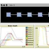
Marco Janssen Irene Perez Ibarra | Published Wednesday, January 09, 2013 | Last modified Saturday, April 27, 2013This is a replication of the Pumpa model that simulates the Pumpa Irrigation System in Nepal (Cifdaloz et al., 2010).
Agent-based Line-of-Sight Simulation for safer Crossings (Short Paper - Netlogo Model)
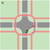
Vincent Franke | Published Thursday, August 05, 2021This software simulates cars and bicycles as traffic participants while crossing different crossroad designs such as roundabouts, protected crossroads and standard crossroads. It is written in Netlogo 6.2 and aims to identify safety characteristics of these layouts using agent-based modeling. Participants track the line of sight to each other and print them as an output alongside with the adjacent destination, used layout, count of collisions/cars/bicycles and time.
Detailed information can be found within the info tab of the program itself.

Gaming Polarisation: Using Agent-Based Simulations as A Dialogue Tool
Shaoni Wang | Published Friday, May 09, 2025This model aims to replicate the evolution of opinions and behaviours on a communal plan over time. It also aims to foster community dialogue on simulation outcomes, promoting inclusivity and engagement. Individuals (referred to as agents), grouped based on Sinus Milieus (Groh-Samberg et al., 2023), face a binary choice: support or oppose the plan. Motivated by experiential, social, and value needs (Antosz et al., 2019), their decision is influenced by how well the plan aligns with these fundamental needs.
Gini Palma microsimulation
Edgar Oliveira | Published Wednesday, December 11, 2024The model is a microsimulation, where the agents don’t Interact with each other. It simulates income distribution, unemployment dynamics, education, and Family grant in Brazil, focusing on the impact on social inequality. It tracks the indicators Gini index, Lorenz curve, and Palma ratio. The objective is to explore how these factors influence wealth distribution and social inequality over time.
This work was developed in partnership with the Graduate Program in Computational Modeling, in the Universidade Federal do Rio Grande - FURG, in Brazil.
Demographic microsimulation for individuals and couples
Sabine Zinn | Published Wednesday, January 14, 2015The simulation model conducts fine-grained population projection by specifying life course dynamics of individuals and couples by means of traditional demographic microsimulation and by using agent-based modeling for mate matching.
(De-)Stabilising effect of diffusions
Julia Kasmire Bert Van Meeuwen Cornelis Eikelboom | Published Tuesday, August 11, 2015What is stable: the large but coordinated change during a diffusion or the small but constant and uncoordinated changes during a dynamic equilibrium? This agent-based model of a diffusion creates output that reveal insights for system stability.
Tyche
Tony Lawson | Published Tuesday, February 28, 2012 | Last modified Saturday, April 27, 2013Demographic microsimulation model used in speed tests against LIAM 2.
Feedback Loop Example: Vegetation Patch Growth
James Millington | Published Thursday, December 20, 2012 | Last modified Saturday, April 27, 2013This model illustrates a positive ‘growth’ feedback loop in which the areal extent of an entity increases through time.
Peer reviewed ELTAP-Egy model (Energy Landscape Transition Analysis and Planning in Egypt)
Mostafa Shaaban Jürgen Scheffran Jürgen Böhner Mohamed Salah Elsobki | Published Saturday, December 29, 2018The model investigates conditions, scenarios and strategies for future planning of energy in Egypt, with an emphasis on alternative energy pathways and a sustainable electricity supply mix as part of an energy roadmap till the year 2100. It combines the multi-criteria decision analysis (MCDA) with agent-based modeling (ABM) and Geographic Information Systems (GIS) visualization to integrate the interactions of the decisions of multi-agents, the multi-criteria evaluation of sustainability, the time factor and the site factors to assess the transformation of energy landscapes.
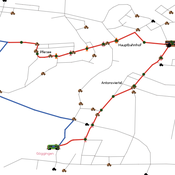
Simulating changing traffic flow caused by new bus route in Augsburg
Eduard | Published Wednesday, August 04, 2021This is a Netlogo model which simulates car and bus/tram traffic in Augsburg, specifically between the districts Stadtbergen, Göggingen and the Königsplatz. People either use their cars or public transport to travel to one of their random destinations (Stadtbergen or Göggingen), performing some activity and then returning to their home. Attributes such as travel and waiting time as well as their happiness upon arriving are stored and have an impact on individuals on whether they would consider changing their mode of transport or not.
Displaying 10 of 506 results for "Tim M Daw" clear search