About the CoMSES Model Library more info
Our mission is to help computational modelers at all levels engage in the establishment and adoption of community standards and good practices for developing and sharing computational models. Model authors can freely publish their model source code in the Computational Model Library alongside narrative documentation, open science metadata, and other emerging open science norms that facilitate software citation, reproducibility, interoperability, and reuse. Model authors can also request peer review of their computational models to receive a DOI.
All users of models published in the library must cite model authors when they use and benefit from their code.
Please check out our model publishing tutorial and contact us if you have any questions or concerns about publishing your model(s) in the Computational Model Library.
We also maintain a curated database of over 7500 publications of agent-based and individual based models with additional detailed metadata on availability of code and bibliometric information on the landscape of ABM/IBM publications that we welcome you to explore.
Displaying 10 of 55 results region clear search
Retail Competition Agent-based Model
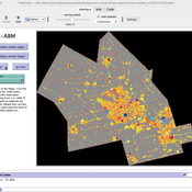
Jiaxin Zhang Derek Robinson | Published Sunday, January 03, 2021 | Last modified Wednesday, November 10, 2021The Retail Competition Agent-based Model (RC-ABM) is designed to simulate the retail competition system in the Region of Waterloo, Ontario, Canada, which which explicitly represents store competition behaviour. Through the RC-ABM, we aim to answer 4 research questions: 1) What is the level of correspondence between market share and revenue acquisition for an agent-based approach compared to a traditional location-allocation-based approach? 2) To what degree can the observed store spatial pattern be reproduced by competition? 3) To what degree are their path dependent patterns of retail success? 4) What is the relationship between retail survival and the endogenous geographic characteristics of stores and consumer expenditures?
SAFARI: Simulating Agroforestry Adoption in Rural Indonesia
Beatrice Nöldeke Etti Winter Yves Laumonier Trifosa Simamora | Published Tuesday, July 20, 2021The Simulating Agroforestry Adoption in Rural Indonesia (SAFARI) model aims at exploring the adoption of illipe rubber agroforestry systems by farming households in the case study region in rural Indonesia. Thereby, the ABM simulates the interdependencies of agroforestry systems and local livelihoods, income, land use, biodiversity, and carbon fixation. The model contrasts development paths without agroforestry (business as usual (BAU) scenario), corresponding to a scenario where the government promotes rubber monoculture, with the introduction of illipe rubber agroforestry systems (IRA scenario) as an alternative. It aims to support policy-makers to assess the potential of IRA over larger temporal and spatial scales.
Human Environment Estuarine Systems Investigator
Andrew Allison | Published Friday, February 26, 2021This model simulates the form and function of an idealised estuary with associated barrier-spit complex on the north east coast of New Zealand’s North Island (from Bream Bay to central Bay of Plenty) during the years 2010 - 2050 CE. It combines variables from social, ecological and geomorphic systems to simulate potential directions of change in shallow coastal systems in response to external forcing from land use, climate, pollution, population density, demographics, values and beliefs. The estuary is over 1000Ha, making it a large estuary according to Hume et al. (2007) - there are 12 large estuaries in the Auckland region alone (Suyadi et al., 2019). The model was developed as part of Andrew Allison’s PhD Thesis in Geography from the School of Environment and Institute of Marine Science, University of Auckland, New Zealand. The model setup allows for alteration of geomorphic, ecological and social variables to suit the specific conditions found in various estuaries along the north east coast of New Zealand’s North Island.
This model is not a predictive or forecasting model. It is designed to investigate potential directions of change in complex shallow coastal systems. This model must not be used for any purpose other than as a heuristic to facilitate researcher and stakeholder learning and for developing system understanding (as per Allison et al., 2018).
COVID-19 ABM
Gudrun Wallentin | Published Tuesday, April 21, 2020 | Last modified Tuesday, April 21, 2020Model of the Corona pandemic outbreak
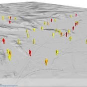
The COVID-19 ABM aims to predict the qualitative behaviour of the CoViD-19 epidemic dynamics for the greater region of Salzburg City. Specifically, by means of scenario testing, it aims to help assessing how containment interventions can allow a stepwise relaxation of the lockdown without risking a new outbreak.
FlowLogo for a real case study
Vahid Aghaie | Published Monday, May 18, 2020Juan Castilla-Rho et al. (2015) developed a platform, named FLowLogo, which integrates a 2D, finite-difference solution of the governing equations of groundwater flow with agent-based simulation. We used this model for Rafsanjan Aquifer, which is located in an arid region in Iran. To use FLowLogo for a real case study, one needs to add GIS shapefiles of boundary conditions and modify the code written in NetLogo a little bit. The FlowLogo model used in our research is presented here.
Traffic and Shipments out of Inter-Firm Communication in a Textile Industrial District
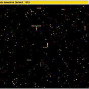
Guido Fioretti Guido Fioretti | Published Monday, April 27, 2020This article presents an agent-based model of an Italian textile district where thousands of small firms specialize in particular phases of fabrics production. It reconstructs the web of communication between firms as they arrange production chains. In turn, production chains result in road traffic between the geographical areas on which the district extends. The reconstructed traffic exhibits a pattern that has been observed, but not foreseen, by policy makers.
Hybrid Agent-Based and Equation Based Model for Infectious Disease Spread
Elizabeth Hunter Brian Mac Namee John Kelleher | Published Sunday, April 19, 2020Our model is hybrid agent-based and equation based model for human air-borne infectious diseases measles. It follows an SEIR (susceptible, exposed,infected, and recovered) type compartmental model with the agents moving be-tween the four state relating to infectiousness. However, the disease model canswitch back and forth between agent-based and equation based depending onthe number of infected agents. Our society model is specific using the datato create a realistic synthetic population for a county in Ireland. The modelincludes transportation with agents moving between their current location anddesired destination using predetermined destinations or destinations selectedusing a gravity model.
Modeling the decline of labor-sharing in highly variable environments
Andres Baeza-Castro Marco Janssen | Published Tuesday, April 02, 2019The rapid environmental changes currently underway in many dry regions of the world, and the deep uncertainty about their consequences, underscore a critical challenge for sustainability: how to maintain cooperation that ensures the provision of natural resources when the benefits of cooperating are variable, sometimes uncertain, and often limited. We present an agent-based model that simulates the economic decisions of households to engage, or not, in labor-sharing agreements under different scenarios of water supply, water variability, and socio-environmental risk. We formulate the model to investigate the consequences of environmental variability on the fate of labor-sharing agreements between farmers. The economic decisions were implemented in the framework of prospect theory.
Cliff Walking with Q-Learning NetLogo Extension
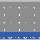
Kevin Kons Fernando Santos | Published Tuesday, December 10, 2019This model implements a classic scenario used in Reinforcement Learning problem, the “Cliff Walking Problem”. Consider the gridworld shown below (SUTTON; BARTO, 2018). This is a standard undiscounted, episodic task, with start and goal states, and the usual actions causing movement up, down, right, and left. Reward is -1 on all transitions except those into the region marked “The Cliff.” Stepping into this region incurs a reward of -100 and sends the agent instantly back to the start (SUTTON; BARTO, 2018).
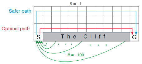
The problem is solved in this model using the Q-Learning algorithm. The algorithm is implemented with the support of the NetLogo Q-Learning Extension
CHAAHK: a Spatial Simulation of the Maya Elevated Core Region
Alex Kara | Published Tuesday, December 04, 2018 | Last modified Thursday, September 26, 2019This thesis presents an abstract spatial simulation model of the Maya Central Lowlands coupled human and natural system from 1000 BCE to the present day. It’s name is the Climatically Heightened but Anothropogenically Achieved Historical Kerplunk model (CHAAHK). The simulation features features virtual human groups, population centers, transit routes, local resources, and imported resources. Despite its embryonic state, the model demonstrates how certain anthropogenic characteristics of a landscape can interact with externally induced trauma and result in a prolonged period of relative sociopolitical uncomplexity. Analysis of batch simulation output suggests decreasing empirical uncertainties about ancient wetland modification warrants more investment. This first submission of CHAAHK’s code represents the simulation’s implementation that was featured in the author’s master’s thesis.
Displaying 10 of 55 results region clear search
