About the CoMSES Model Library more info
Our mission is to help computational modelers at all levels engage in the establishment and adoption of community standards and good practices for developing and sharing computational models. Model authors can freely publish their model source code in the Computational Model Library alongside narrative documentation, open science metadata, and other emerging open science norms that facilitate software citation, reproducibility, interoperability, and reuse. Model authors can also request peer review of their computational models to receive a DOI.
All users of models published in the library must cite model authors when they use and benefit from their code.
Please check out our model publishing tutorial and contact us if you have any questions or concerns about publishing your model(s) in the Computational Model Library.
We also maintain a curated database of over 7500 publications of agent-based and individual based models with additional detailed metadata on availability of code and bibliometric information on the landscape of ABM/IBM publications that we welcome you to explore.
Displaying 10 of 98 results for "Andrew Yoak" clear search
Irrigation Equity and Efficiency
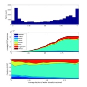
Andrew Bell | Published Tuesday, August 30, 2016The purpose of this model is to examine equity and efficiency in crop production across a system of irrigated farms, as a function of maintenance costs, assessed water fees, and the capacity of farmers to trade water rights among themselves.
ForagerNet3_Demography_V3
Andrew White | Published Tuesday, November 29, 2016The ForagerNet3_Demography model is a non-spatial ABM designed to serve as a platform for exploring several aspects of hunter-gatherer demography.
Exploring Urban Shrinkage
Andrew Crooks | Published Thursday, March 19, 2020While the world’s total urban population continues to grow, this growth is not equal. Some cities are declining, resulting in urban shrinkage which is now a global phenomenon. Many problems emerge due to urban shrinkage including population loss, economic depression, vacant properties and the contraction of housing markets. To explore this issue, this paper presents an agent-based model stylized on spatially explicit data of Detroit Tri-county area, an area witnessing urban shrinkage. Specifically, the model examines how micro-level housing trades impact urban shrinkage by capturing interactions between sellers and buyers within different sub-housing markets. The stylized model results highlight not only how we can simulate housing transactions but the aggregate market conditions relating to urban shrinkage (i.e., the contraction of housing markets). To this end, the paper demonstrates the potential of simulation to explore urban shrinkage and potentially offers a means to test polices to alleviate this issue.
Human-in-the-loop Experiment of the Strategic Coalition Formation using the glove game
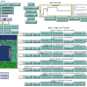
Andrew Collins | Published Monday, November 23, 2020 | Last modified Wednesday, June 22, 2022The purpose of the model is to collect information on human decision-making in the context of coalition formation games. The model uses a human-in-the-loop approach, and a single human is involved in each trial. All other agents are controlled by the ABMSCORE algorithm (Vernon-Bido and Collins 2020), which is an extension of the algorithm created by Collins and Frydenlund (2018). The glove game, a standard cooperative game, is used as the model scenario.
The intent of the game is to collection information on the human players behavior and how that compares to the computerized agents behavior. The final coalition structure of the game is compared to an ideal output (the core of the games).
Multi-Hazard Coastal Agent-Based Model (MHCABM)
Andrew Allison | Published Thursday, August 05, 2021MHCABM is an agent-based, multi-hazard risk interaction model with an integrated applied dynamic adaptive pathways planning component. It is designed to explore the impacts of climate change adaptation decisions on the form and function of a coastal human-environment system, using as a case study an idealised patch based representation of the Mount North-Omanu area of Tauranga city, New Zealand. The interacting hazards represented are erosion, inundation, groundwater intrusion driven by intermittent heavy rainfall / inundations (storm) impacts, and sea level rise.
Style_Net_01
Andrew White | Published Tuesday, August 03, 2021Style_Net_01 is a spatial agent-based model designed to serve as a platform for exploring geographic patterns of tool transport and discard among seasonally mobile hunter-gatherer populations. The model has four main levels: artifact, person, group, and system. Persons make, use, and discard artifacts. Persons travel in groups within the geographic space of the model. The movements of groups represent a seasonal pattern of aggregation and dispersal, with all groups coalescing at an aggregation site during one point of the yearly cycle. The scale of group mobility is controlled by a parameter. The creation, use, and discard of artifacts is controlled by several parameters that specify how many tools each person carries in a personal inventory, how many times each tool can be used before it is discarded, and the frequency of tool usage. A lithic source (representing a geographically-specific, recognizable source of stone for tools) can be placed anywhere in the geographic space of the model.
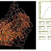
Modelling Farmers’ Adoption Potential to New Bioenergy Crops
Andrew Crooks | Published Tuesday, November 29, 2022A model that representa farmers potential to adopt bio-fuels in Georgia
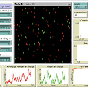
“Food for all” (FFD)
José Santos José Manuel Galán Andreas Angourakis Andrea L Balbo | Published Friday, April 25, 2014 | Last modified Monday, April 08, 2019“Food for all” (FFD) is an agent-based model designed to study the evolution of cooperation for food storage. Households face the social dilemma of whether to store food in a corporate stock or to keep it in a private stock.
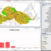
Modeling the Emergence of Riots
Bianica Pires Andrew Crooks | Published Wednesday, January 20, 2016 | Last modified Wednesday, September 21, 2016The purpose of the model is to explore how the unique socioeconomic variables underlying Kibera, local interactions, and the spread of a rumor, may trigger a riot.
The Geography of Conflict Diamonds: The Case of Sierra Leone
Bianica Pires Andrew Crooks | Published Thursday, March 24, 2016 | Last modified Thursday, March 24, 2016Using Sierra Leone as a test case, the purpose of the model is to explore the role of geography in a resource-driven war. An ABM is integrated with geographic information systems (GIS) for this purpose.
Displaying 10 of 98 results for "Andrew Yoak" clear search