About the CoMSES Model Library more info
Our mission is to help computational modelers at all levels engage in the establishment and adoption of community standards and good practices for developing and sharing computational models. Model authors can freely publish their model source code in the Computational Model Library alongside narrative documentation, open science metadata, and other emerging open science norms that facilitate software citation, reproducibility, interoperability, and reuse. Model authors can also request peer review of their computational models to receive a DOI.
All users of models published in the library must cite model authors when they use and benefit from their code.
Please check out our model publishing tutorial and contact us if you have any questions or concerns about publishing your model(s) in the Computational Model Library.
We also maintain a curated database of over 7500 publications of agent-based and individual based models with additional detailed metadata on availability of code and bibliometric information on the landscape of ABM/IBM publications that we welcome you to explore.
Displaying 10 of 322 results for "John Nay" clear search
Demand Planning Model
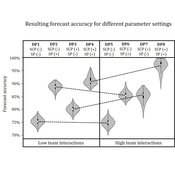
Iris Lorscheid Jonas Hauke Matthias Meyer | Published Wednesday, October 04, 2017Demand planning requires processing of distributed information. In this process, individuals, their properties and interactions play a crucial role. This model is a computational testbed to investigate these aspects with respect to forecast accuracy.
Simulating Components of the Reinforcing Spirals Model and Spiral of Silence
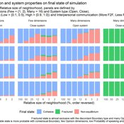
František Kalvas Michael D. Slater Ashley Sanders-Jackson | Published Friday, November 05, 2021Communication processes occur in complex dynamic systems impacted by person attitudes and beliefs, environmental affordances, interpersonal interactions and other variables that all change over time. Many of the current approaches utilized by Communication researchers are unable to consider the full complexity of communication systems or the over time nature of our data. We apply agent-based modeling to the Reinforcing Spirals Model and the Spiral of Silence to better elucidate the complex and dynamic nature of this process. Our preliminary results illustrate how environmental affordances (i.e. social media), closeness of the system and probability of outspokenness may impact how attitudes change over time. Additional analyses are also proposed.
Simulating the Ridesharing Economy: The Individual Agent Metro-Washington Area Ridesharing Model (IAMWARM)
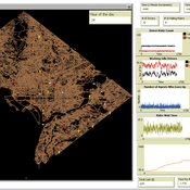
Joseph A. E. Shaheen | Published Thursday, January 27, 2022This is a ridesharing model (Uber/Lyft) of the larger Washington DC metro area. The model can be modified (Netlogo 6.x) relatively easily and be adapted to any metro area. Please cite generously (this was a lot of work) and please cite the paper, not the comses model.
Link to the paper published in “Complex Adaptive Systems” here: https://link.springer.com/chapter/10.1007/978-3-030-20309-2_7
Citation: Shaheen J.A.E. (2019) Simulating the Ridesharing Economy: The Individual Agent Metro-Washington Area Ridesharing Model (IAMWARM). In: Carmichael T., Collins A., Hadžikadić M. (eds) Complex Adaptive Systems. Understanding Complex Systems. Springer, Cham. https://doi.org/10.1007/978-3-030-20309-2_7
Risk perception of individuals and the transmission dynamics of COVID-19
Sara Shahin Moghadam Franziska klügel | Published Tuesday, June 27, 2023The purpose of this model is to explore the influence of integrating individuals’ behavioral dynamics in an agent-based model of COVID-19, on the dynamics of disease transmission. The model is an agent-based extention of an established large-scale Individual-based model called STRIDE. Four risk factors determine the individual’s perception of the risk and how they behave accordingly. It is assumed that individuals with higher levels of risk perception adopt higher levels of contact reduction in their daily routines. Individuals can assign different weights to any of the four different risk factors, i.e., the modeler can model different populations and explore how the transmission dynamics vary among them.
Peer reviewed SequiaBasalto model
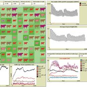
Marco Janssen Irene Perez Ibarra Pierre Bommel Diego J. Soler-Navarro Alicia Tenza Peral Francisco Dieguez Cameroni | Published Friday, May 26, 2023This is a replication of the SequiaBasalto model, originally built in Cormas by Dieguez Cameroni et al. (2012, 2014, Bommel et al. 2014 and Morales et al. 2015). The model aimed to test various adaptations of livestock producers to the drought phenomenon provoked by climate change. For that purpose, it simulates the behavior of one livestock farm in the Basaltic Region of Uruguay. The model incorporates the price of livestock, fodder and paddocks, as well as the growth of grass as a function of climate and seasons (environmental submodel), the life cycle of animals feeding on the pasture (livestock submodel), and the different strategies used by farmers to manage their livestock (management submodel). The purpose of the model is to analyze to what degree the common management practices used by farmers (i.e., proactive and reactive) to cope with seasonal and interannual climate variations allow to maintain a sustainable livestock production without depleting the natural resources (i.e., pasture). Here, we replicate the environmental and livestock submodel using NetLogo.
One year is 368 days. Seasons change every 92 days. Each day begins with the growth of grass as a function of climate and season. This is followed by updating the live weight of cows according to the grass height of their patch, and grass consumption, which is determined based on the updated live weight. After consumption, cows grow and reproduce, and a new grass height is calculated. Cows then move to the patch with less cows and with the highest grass height. This updated grass height value will be the initial grass height for the next day.
A test-bed ecological model
Bruce Edmonds | Published Sunday, May 04, 2014 | Last modified Wednesday, May 15, 2019This is a multi-patch meta-population ecological model. It intended as a test-bed in which to test the impact of humans with different kinds of social structure.
Implementation of 'satisficing’ as a model for farmers’ decision-making in an agent-based model of groundwater over-exploitation
Marvin Nebel | Published Monday, May 20, 2013This model uses ’satisficing’ as a model for farmers’ decision making to learn about influences of alternative decision-making models on simulation results and to exemplify a way to transform a rather theoretical concept into a feasible decision-making model for agent-based farming models.
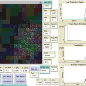
How does the world population adapt its policies on energy when it is confronted with a climate change? This model combines a climate-economy model with adaptive agents.
Evolutionary Prosocial Behavior Algorithm 1.1 (EPBA_1.1)
Andrea Ceschi | Published Tuesday, September 04, 2018In order to test how prosocial strategies (compassionate altruism vs. reciprocity) grow over time, we developed an evolutionary simulation model where artificial agents are equipped with different emotionally-based drivers that vary in strength. Evolutionary algorithms mimic the evolutionary selection process by letting the chances of agents conceiving offspring depend on their fitness. Equipping the agents with heritable prosocial strategies allows for a selection of those strategies that result in the highest fitness. Since some prosocial attributes may be more successful than others, an initially heterogeneous population can specialize towards altruism or reciprocity. The success of particular prosocial strategies is also expected to depend on the cultural norms and environmental conditions the agents live in.
CHAAHK: a Spatial Simulation of the Maya Elevated Core Region
Alex Kara | Published Tuesday, December 04, 2018 | Last modified Thursday, September 26, 2019This thesis presents an abstract spatial simulation model of the Maya Central Lowlands coupled human and natural system from 1000 BCE to the present day. It’s name is the Climatically Heightened but Anothropogenically Achieved Historical Kerplunk model (CHAAHK). The simulation features features virtual human groups, population centers, transit routes, local resources, and imported resources. Despite its embryonic state, the model demonstrates how certain anthropogenic characteristics of a landscape can interact with externally induced trauma and result in a prolonged period of relative sociopolitical uncomplexity. Analysis of batch simulation output suggests decreasing empirical uncertainties about ancient wetland modification warrants more investment. This first submission of CHAAHK’s code represents the simulation’s implementation that was featured in the author’s master’s thesis.
Displaying 10 of 322 results for "John Nay" clear search
