Deforestation 1.1.0
Deforestation Simulation Model in NetLogo with GIS Layers
This model has developed in Netlogo software and utilizes
the GIS extension.
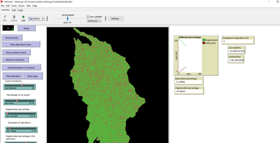
This NetLogo-based agent-based model (ABM) simulates deforestation dynamics using the GIS extension. It incorporates parameters like wood extraction, forest regeneration, agricultural expansion, and livestock impact. The model integrates spatial layers, including forest areas, agriculture zones, rural settlements, elevation, slope, and livestock distribution. Outputs include real-time graphical representations of forest loss, regeneration, and land-use changes. This model helps analyze deforestation patterns and conservation strategies using ABM and GIS.

Release Notes
Deforestation Simulation Model in NetLogo with GIS Layers
This agent-based model, developed in NetLogo (2017) using the GIS extension, simulates deforestation dynamics influenced by multiple ecological and anthropogenic factors.
Model Parameters
The simulation incorporates key parameters, including:
- Number of animals impacting forest density
- Percentage of wood extraction (deforestation intensity)
- Forest regeneration rate in different zones
- Agricultural expansion percentage
- Sanctuary regeneration rate
- GIS-Integrated Spatial Layers
The model leverages spatial data to enhance realism, integrating:
- Forest areas and their spatial extent
- Agricultural zones and rural settlements
- Livestock distribution points
- Distance to livestock centers affecting forest degradation
- Elevation and slope influencing land-use patterns
Dynamic Outputs
The model provides real-time graphical representations of:
- Forest loss and regeneration percentages over time
- Spatial evolution of deforestation and agricultural expansion
This model offers valuable insights into land-use change, deforestation patterns, and potential conservation strategies by integrating GIS-based spatial data with ABM principles.